
The alignment of Route 3113 at the Batu Maung interchange of P2B shown on the MfM 140303 map reflects the previous situation when the interchange was still under construction. I have included the tracks showing the current (straightened) alignment.
Other corrections are also included in this file.
tympg 20140303 3113 realignment.gdb
Thanks.
Penang, Kedah, Perlis Change/Error Feedback 2014
Moderators: tympg, keong8260, Moderators, Regional Mappers
Re: Penang, Kedah, Perlis Change/Error Feedback 2014
Garmin nüvi 2575R; Garmin eTrex Vista HCx; Android 5.0.1 Phone
Re: Penang, Kedah, Perlis Change/Error Feedback 2014
To delete duplicate Bank POI.
tympg 20140307 del dupl bank POI.gdb
Thanks.
Done! 443 - OngCC
tympg 20140307 del dupl bank POI.gdb
Thanks.
Done! 443 - OngCC
Garmin nüvi 2575R; Garmin eTrex Vista HCx; Android 5.0.1 Phone

Re: Penang, Kedah, Perlis Change/Error Feedback 2014
tklew 140316 link the road
tklew 140316 pusat perniagaan
tklew 140316 seri impian
tklew 140316 tesco
tklew 140316 pusat perniagaan
tklew 140316 seri impian
tklew 140316 tesco
You do not have the required permissions to view the files attached to this post.
水穷之处待云起 , 危崖旁侧觅坦途
Anything could happen
Anything could happen
Re: Penang, Kedah, Perlis Change/Error Feedback 2014
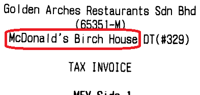
Please delete duplicate McDonald's at N5.41293 E100.32612 and rename to the official name "McDonald's Birch House (with Drive-Thru)":
Garmin nüvi 2575R; Garmin eTrex Vista HCx; Android 5.0.1 Phone
Re: Penang, Kedah, Perlis Change/Error Feedback 2014
At N5.29638 E100.26695, when routing in MapSource or Garmin device, coming from Bayan Baru on Jln Sultan Azlan Shah on the way to Penang Airport, the navigation route suggests the user to go to the roundabout, then turn left into the airport road.
In fact, the user can avoid the roundabout altogether by taking the little ramp I indicated in the diagram above. I guess this is about adjusting the route class of the ramp.
Thanks.
Done! 444, please help to verify on the next release - OngCC
In fact, the user can avoid the roundabout altogether by taking the little ramp I indicated in the diagram above. I guess this is about adjusting the route class of the ramp.
Thanks.
Done! 444, please help to verify on the next release - OngCC
You do not have the required permissions to view the files attached to this post.
Garmin nüvi 2575R; Garmin eTrex Vista HCx; Android 5.0.1 Phone

Re: Penang, Kedah, Perlis Change/Error Feedback 2014
I have fedback this before but maybe to wrong post.
The Lengkok Perak N5 24.273 E100 19.227 (whole stretch between Jalan Sungai Pinang and Jalan Maklom) should be removed.
Ever since I've been living in Penang more than 20 years ago, a factory building was on the stretch. Recently, it becomes Volkswagen sales office/showroom just next to Volvo which has been there long before I started working in Penang.
You cannot see any trace of road there actually because the factory (now Volkswagen) wall is like a tall fence to Taman Pinang flat there, sharing same drainage. I know because my sister-in-law stays there
Done! 444 - OngCC
Re: Penang, Kedah, Perlis Change/Error Feedback 2014
tympg wrote:At N5.29638 E100.26695, when routing in MapSource or Garmin device, coming from Bayan Baru on Jln Sultan Azlan Shah on the way to Penang Airport, the navigation route suggests the user to go to the roundabout, then turn left into the airport road.
In fact, the user can avoid the roundabout altogether by taking the little ramp I indicated in the diagram above. I guess this is about adjusting the route class of the ramp.
Thanks.
Done! 444, please help to verify on the next release - OngCC
Unfortunately still the same on MFM-Garmin 140331; Garmin will route to roundabout instead of taking the ramp.
Garmin nüvi 2575R; Garmin eTrex Vista HCx; Android 5.0.1 Phone
Re: Penang, Kedah, Perlis Change/Error Feedback 2014
Pizza Hut
Central Square, Sungai Petani – closed
KFC
Lorong 10 (Taman Sejati Indah) – moved to new location below
Choon Nam Restaurant (Taman Sejati Indah, Sungai Petani) is now KFC (the new location)
* Choon Nam Restaurant is in database
Done! 446 - OngCC
Central Square, Sungai Petani – closed
KFC
Lorong 10 (Taman Sejati Indah) – moved to new location below
Choon Nam Restaurant (Taman Sejati Indah, Sungai Petani) is now KFC (the new location)
* Choon Nam Restaurant is in database
Done! 446 - OngCC
Re: Penang, Kedah, Perlis Change/Error Feedback 2014
Section of George Town street turned into one-way. From NW to SE.
tympg 20140425 One-Way.gdb
Thanks.
tympg 20140425 One-Way.gdb
Thanks.
Garmin nüvi 2575R; Garmin eTrex Vista HCx; Android 5.0.1 Phone
Re: Penang, Kedah, Perlis Change/Error Feedback 2014
George Town:
Sepoy Lines Rd from Jalan Residensi (N5.41759 E100.31026) to Sepoy Lines junction (N5.41995 E100.30629) is ONE WAY effective Saturday 26 April 2014.
Source: MPPP Announcement Document (PDF)
Thanks.
Sepoy Lines Rd from Jalan Residensi (N5.41759 E100.31026) to Sepoy Lines junction (N5.41995 E100.30629) is ONE WAY effective Saturday 26 April 2014.
Source: MPPP Announcement Document (PDF)
Thanks.
Garmin nüvi 2575R; Garmin eTrex Vista HCx; Android 5.0.1 Phone
Who is online
Users browsing this forum: No registered users and 5 guests