

There are a few key decisions to make before we can start.
1. How detail? Quality or quantity?
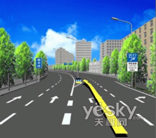
Junction view can be very detail
or
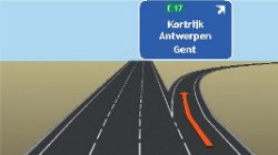
very simple
Obviously we need to spend a lot of time and need talented artists to create detail junction views. Or we can spend relatively little time preparing generic junction views
2. Data acquisition method
We do not have cars fitted with video cameras and paid drivers driving around a city to capture pictures of junctions. Taking pictures while driving can be dangerous. Will our members endanger their own lives and lives of others if they help us take pictures of junctions? Is there another way? Ideas?
3. In-house or outsource?
So far, all of MFM's content is produced by our own members with some based on public domain data. There are other parties that are interested to work together with us. These parties may have the resources that we don't. So do we create junction view ourselves or work with another party?
So dear members, please think hard and share your wisdom
Btw, the same issue applies to 3D buildings but since junction view is more useful for navigation, we will discuss junction view first.
UPDATE 7/12/2009
After 6 months of creating JV graphics, we had settled upon some procedures and guidelines. In the process, we have created over 2,000 JV graphics!
Along with some JV produced by Papago, users of MFM-Papago can enjoy JV pictures at more than 1,000 locations. Refer to the GDB file below for MFM JV locations.
Only a handful people were actively involved in the MFM JV project but they contributed tremendously. Kudos to bros Edchuang, Chuah and Johntan for drawing the JV graphics. Thanks also to bros Kafie1980, Anglekit, Buggs, Trekker1, Sulphur and Barnes for various contributions.


 ). I may be wrong, but I don't think we have that many members who are really really good in doing fully rendered perspective view of these junctions. The simple view could quite easily be handled by most modern graphic packages (I'm guessing here).


 antyong