
Route 231 -- extension of dual carriageway to Airport roundabout. Includes a set of U-turns and a new connection to a residential road.
tympg 20140220 Airport Rd 2-cwy expansion.7z
Thanks.
Penang Island Tracks Pt 4
Moderators: tympg, keong8260, Moderators, Regional Mappers
Forum rules
1. Be nice to each other and respect the moderators. Post in normal font size, color and weight. Follow Nettiquette
2. NO out of topic. This forum is strictly for feedback to our maps
3. NO posting of data copied from other source especially malsingmaps
4. NO abuse, profanity and insults
5. NO spamming, cross posting and opening of duplicate topics
6. NO post/link to warez, cracks, serials or illegally obtained copyrighted content
7. Each message posted is owned by and is the opinion of the original poster. Neither mfm nor its owner or moderators are legally responsible for anything posted on the forum
Re: Penang Island Tracks Pt 4
Garmin nüvi 2575R; Garmin eTrex Vista HCx; Android 5.0.1 Phone

Re: Penang Island Tracks Pt 4
tklew 140227 Meridien Residence
Upload files to this drop box : NPM
Done! 442 - OngCC
Upload files to this drop box : NPM
Done! 442 - OngCC
水穷之处待云起 , 危崖旁侧觅坦途
Anything could happen
Anything could happen
Re: Penang Island Tracks Pt 4
Some roads leading to TNB substations and the UEM office. These roads are underneath the island end of the Second Bridge.
You can only access these roads by coming from 3113 (S) > keep left to Penang Second Bridge Ramp > turn into this road.
You can only exit by joining back to 3113 (S) towards Batu Maung.
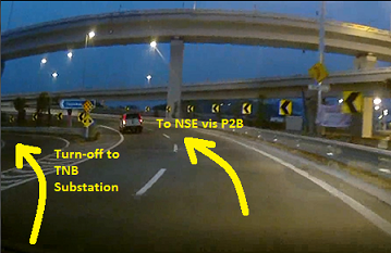
tympg 20140306 TNB road.7z
Note the "one-way-ness" of certain sections of the roads.
Thanks.
Done! 443 - OngCC
You can only access these roads by coming from 3113 (S) > keep left to Penang Second Bridge Ramp > turn into this road.
You can only exit by joining back to 3113 (S) towards Batu Maung.
tympg 20140306 TNB road.7z
Note the "one-way-ness" of certain sections of the roads.
Thanks.
Done! 443 - OngCC
Garmin nüvi 2575R; Garmin eTrex Vista HCx; Android 5.0.1 Phone
Re: Penang Island Tracks Pt 4
Shineville residential project.
Consists of three sections:
tympg 20140413 Shineville.7z
Thanks.
Done! 446 - OngCC
Consists of three sections:
- Shineville Villas (terrace houses)
- Shineville Park Condominium
- Shineville Garden (apartments)
tympg 20140413 Shineville.7z
Thanks.
Done! 446 - OngCC
Garmin nüvi 2575R; Garmin eTrex Vista HCx; Android 5.0.1 Phone
Re: Penang Island Tracks Pt 4
Tracks for recently opened McDonald's.
tympg 20140524 McD Sg Pinang.7z
Also included, realignment & connection of nearby roads.
Thanks.
tympg 20140524 McD Sg Pinang.7z
Also included, realignment & connection of nearby roads.
Thanks.
Garmin nüvi 2575R; Garmin eTrex Vista HCx; Android 5.0.1 Phone
Re: Penang Island Tracks Pt 4
Extension of existing service road. Two-way.
tympg 20140527 svc rd ext.7z
Thanks.
Done! 449 - OngCC
tympg 20140527 svc rd ext.7z
Thanks.
Done! 449 - OngCC
Garmin nüvi 2575R; Garmin eTrex Vista HCx; Android 5.0.1 Phone
Re: Penang Island Tracks Pt 4
A major road is now dual-carriageway for about 400+ metres.
Beside this road, a mixed development (commercial & residential) is about ready so I have tracked the internal road and entrance/exit points.
Also, the local river is realigned.
tympg 20140630 d-cwy & mixed dev.7z
Thanks.
Beside this road, a mixed development (commercial & residential) is about ready so I have tracked the internal road and entrance/exit points.
Also, the local river is realigned.
tympg 20140630 d-cwy & mixed dev.7z
Thanks.
Garmin nüvi 2575R; Garmin eTrex Vista HCx; Android 5.0.1 Phone
Re: Penang Island Tracks Pt 4
Adding a service road that serves two petrol stations.
tympg 20140630 add svc rd.7z
Thanks.
Done! 451 - OngCC
tympg 20140630 add svc rd.7z
Thanks.
Done! 451 - OngCC
Garmin nüvi 2575R; Garmin eTrex Vista HCx; Android 5.0.1 Phone
Re: Penang Island Tracks Pt 4
Compound road of a coffee place:
tympg 20140712 sbux trk.7z
Thanks.
tympg 20140712 sbux trk.7z
Thanks.
Garmin nüvi 2575R; Garmin eTrex Vista HCx; Android 5.0.1 Phone
Re: Penang Island Tracks Pt 4
Road to newly opened restaurant and the organisation in whose compound the restaurant sits.
(Also, to delete the POI of the previous restaurant which no longer exists.)
tympg 20140712 restaurant & social org.7z
Thanks.
Done! 452 - OngCC
(Also, to delete the POI of the previous restaurant which no longer exists.)
tympg 20140712 restaurant & social org.7z
Thanks.
Done! 452 - OngCC
Garmin nüvi 2575R; Garmin eTrex Vista HCx; Android 5.0.1 Phone
Return to “Penang, Kedah & Perlis Map Feedback”
Who is online
Users browsing this forum: No registered users and 17 guests