
POI maybank atm
Updated 616 -sunn
Puchong Tracks
Moderators: shawchyn, Moderators, Regional Mappers
Forum rules
1. Be nice to each other and respect the moderators. Post in normal font size, color and weight. Follow Nettiquette
2. NO out of topic. This forum is strictly for feedback to our maps
3. NO posting of data copied from other source especially malsingmaps
4. NO abuse, profanity and insults
5. NO spamming, cross posting and opening of duplicate topics
6. NO post/link to warez, cracks, serials or illegally obtained copyrighted content
7. Each message posted is owned by and is the opinion of the original poster. Neither mfm nor its owner or moderators are legally responsible for anything posted on the forum
-
purpleray

- Valued Contributor
- Posts: 1299
- Joined: Wed Mar 17, 2010 3:44 am
- Location: Puchong - Putrajaya - Alor Gajah - Kuantan
Re: Puchong Tracks
You do not have the required permissions to view the files attached to this post.
PaPaGO! R5800 X8.5.10 MFM-PPG-181204
Caska 133e PaPaGO!X8.5.10 MFM-PPG-181204
Garmin 255W MFM 181203 & MFM-Garmin NT 2015.40
Garmin 2575RLM MFM 181203 & MFM-Garmin NT 2016.20
MapSource v6.16.3 MFM 181203
JCV Lumix DMC-ZR3 14MB 8x
Caska 133e PaPaGO!X8.5.10 MFM-PPG-181204
Garmin 255W MFM 181203 & MFM-Garmin NT 2015.40
Garmin 2575RLM MFM 181203 & MFM-Garmin NT 2016.20
MapSource v6.16.3 MFM 181203
JCV Lumix DMC-ZR3 14MB 8x
-
thiang

- Polygon Mapper
- Posts: 1329
- Joined: Thu Sep 18, 2008 3:15 pm
- Location: USJ (Garmin-Asus A10 Taiwan Version) & Ipad Mini Retina with Street Pilot MY/SG
Re: Puchong Tracks
Primavenue 2, Puchong
Updated 618 -sunn
Updated 618 -sunn
You do not have the required permissions to view the files attached to this post.
山不在高 有仙則名 水不在深 有龍則靈
-
stimix

- Moderator
- Posts: 611
- Joined: Mon Sep 15, 2008 7:53 pm
- Location: Puchong Selangor (Garmin MXT Nokia N8)
Re: Puchong Tracks
1st glimpse on soon to be completed SKVE highway from Putrajaya to Westport  ..yeah 51 KM to be exaxt from the Ayer hitam to plaza to Westport :
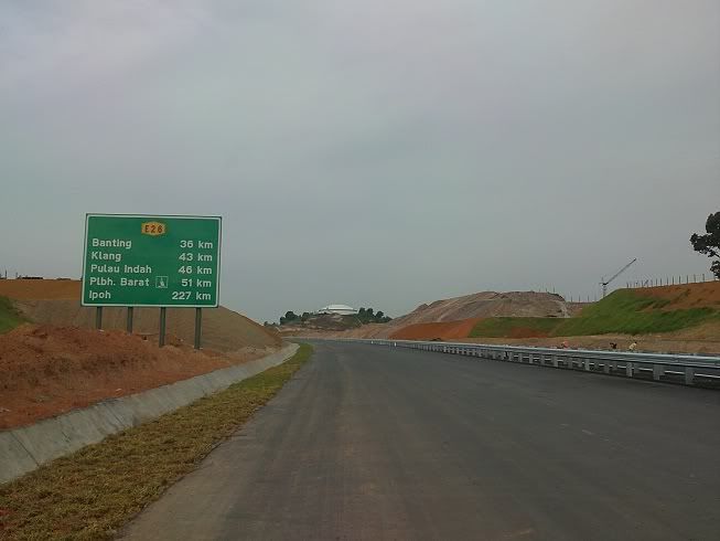
p/s: thanks to Antyong for saving my corrupted gpx file!!
This is also my 1st track using Sony Ericson Vivaz but I think I got the wrong race chrono setting by using 5m/s instead of 1m/s & not data logging](./images/smilies/eusa_wall.gif "Brick wall")
..yeah 51 KM to be exaxt from the Ayer hitam to plaza to Westport :p/s: thanks to Antyong for saving my corrupted gpx file!!
This is also my 1st track using Sony Ericson Vivaz but I think I got the wrong race chrono setting by using 5m/s instead of 1m/s & not data logging
You do not have the required permissions to view the files attached to this post.


Bukit Jalil Track
Bukit Jalil, TPM Exit
From Route Lebuhraya Bukit Jalil towards E2 or E9, Exit Left (Ramp Left) to merge to Jalan Barat to either go to Bukit Jalil Stadium on left or Technology Park Malaysia on right:
Even if you keep on the leftmost lane on the Exit from Bukit Jalil Expressway towards Jalan Barat (indicated by red arrow: location at approximately N 3degree, 2.95'; E 101 degree 41.25') the GPS will not detect that you exit/kept left and are already on the exit lane. You are still considered as being on the main Bukit Jalil Expressway lane. Checked with 2 GPS devices using maps downloaded from this forum as of last Tuesday and it's all the same. I believe the Bukit Jalil Expressway lane might have been skewed to the left a bit at this area, hence a left exit always not detected.
You do not have the required permissions to view the files attached to this post.
-
sunn

- Senior Mapper
- Posts: 3477
- Joined: Sun Sep 14, 2008 12:45 pm
- Location: Shah Alam (HP4150 & SIRF3 BT, HP6515, Etrex Legend HCX, Omnia i900 16GB, Samsung Note 2, Ipad 2
Re: Bukit Jalil Track
shahiman wrote:Bukit Jalil, TPM Exit
From Route Lebuhraya Bukit Jalil towards E2 or E9, Exit Left (Ramp Left) to merge to Jalan Barat to either go to Bukit Jalil Stadium on left or Technology Park Malaysia on right:
Even if you keep on the leftmost lane on the Exit from Bukit Jalil Expressway towards Jalan Barat (indicated by red arrow: location at approximately N 3degree, 2.95'; E 101 degree 41.25') the GPS will not detect that you exit/kept left and are already on the exit lane. You are still considered as being on the main Bukit Jalil Expressway lane. Checked with 2 GPS devices using maps downloaded from this forum as of last Tuesday and it's all the same. I believe the Bukit Jalil Expressway lane might have been skewed to the left a bit at this area, hence a left exit always not detected.
It has been reported that there is blind spots in getting satellite signal in that area. I have updated that ramp.
Please feedback if you still have issue in the next map release.
Regards
It is a merit to forgive others:
The more we forgive the more merit we collect.
(Upload your contribution to MFM drop box if you don't want others to take your contributed tracklogs or POIs. )
The more we forgive the more merit we collect.
(Upload your contribution to MFM drop box if you don't want others to take your contributed tracklogs or POIs. )
-
sunn
- Senior Mapper
- Posts: 3477
- Joined: Sun Sep 14, 2008 12:45 pm
- Location: Shah Alam (HP4150 & SIRF3 BT, HP6515, Etrex Legend HCX, Omnia i900 16GB, Samsung Note 2, Ipad 2
Re: POI: Food
shahiman wrote:Two POIs: details in the image.
1. Azmi Tomyam
2. Koay Teow Mat Rock (5 pm - 12am)
Updated 619 -sunn
shahiman,
In future submission, appreciate that you included the Co-ords just after the POI name rather then in the photos.
e.g: Azmi Tomyam - N2 59.389 E101 37.797.

It is a merit to forgive others:
The more we forgive the more merit we collect.
(Upload your contribution to MFM drop box if you don't want others to take your contributed tracklogs or POIs. )
The more we forgive the more merit we collect.
(Upload your contribution to MFM drop box if you don't want others to take your contributed tracklogs or POIs. )
Re: Puchong Tracks
noted bro sunn, coordinate only next time.... thanks for the Bkt Jalil update as well.
-
stimix
- Moderator
- Posts: 611
- Joined: Mon Sep 15, 2008 7:53 pm
- Location: Puchong Selangor (Garmin MXT Nokia N8)
Re: Puchong Tracks
SKVE 2nd attempt...tracking using Sony vivaz really horrible..haizz  Tracklogs gone after Putra perdana althought i have reached & tracked Saujana Putra Interchange & toll gate!!
You do not have the required permissions to view the files attached to this post.


Re: Puchong Tracks
stimix wrote:SKVE 2nd attempt...tracking using Sony vivaz really horrible..haizz
Haiya. I think better change or get another set for tracking!!
Return to “KL & Selangor Map Feedback”
Who is online
Users browsing this forum: No registered users and 31 guests