eTrex Series

Discussions and information on Personal Navigation Device (PND) and hand-held GPS devices.

Moderators: Moderators, Regional Mappers

Forum rules
1. Be nice to each other and respect the moderators. Post in normal font size, color and weight. Follow Nettiquette
2. NO out of topic. Discuss about GPS device only
3. NO abuse, profanity and insults
4. NO spamming, cross posting and opening of duplicate topics
5. NO advertisement post or link
6. NO post/link to warez, cracks, serials or illegally obtained copyrighted content
7. Each message posted is owned by and is the opinion of the original poster. Neither mfm nor its owner or moderators are legally responsible for anything posted on the forum
kiwitonita
Posts: 4
Joined: Tue Feb 24, 2009 4:28 pm
Location: Christchurch, New Zealand
Contact:

Re: eTrex Series

Postby kiwitonita » Sun Jul 05, 2009 4:11 am

lfy81 wrote:... About the bolded part, is it possible that Mapsource is able to open the gpx files after being transfered to the PC? ...

Hi lfy81, yes, MapSource will open the .gpx files either from the GPS itself (after the GPS has been put into Mass Storage Mode) or from your hard drive. If using the Mass Storage Mode method, use File > Open in MapSource and navigate to the GPS which will now be showing as an external drive. Naturally, if you've put the microSD card in to the computer, use MapSource to File > Open wherever the card is.

Save the raw data then you can edit / join / delete sections etc without fear of losing the source data if something goes wrong. In MapSource you can also go View > View in Google Earth to see your data overlayed on GE. Very neat. All the best, Tony

lfy81
Posts: 27
Joined: Sat Mar 28, 2009 3:23 pm
Location: Penang (Garmin Legend HCx)

Re: eTrex Series

Postby lfy81 » Sun Jul 05, 2009 7:04 pm

kiwitonita wrote:
lfy81 wrote:... About the bolded part, is it possible that Mapsource is able to open the gpx files after being transfered to the PC? ...

Hi lfy81, yes, MapSource will open the .gpx files either from the GPS itself (after the GPS has been put into Mass Storage Mode) or from your hard drive. If using the Mass Storage Mode method, use File > Open in MapSource and navigate to the GPS which will now be showing as an external drive. Naturally, if you've put the microSD card in to the computer, use MapSource to File > Open wherever the card is.

Save the raw data then you can edit / join / delete sections etc without fear of losing the source data if something goes wrong. In MapSource you can also go View > View in Google Earth to see your data overlayed on GE. Very neat. All the best, Tony


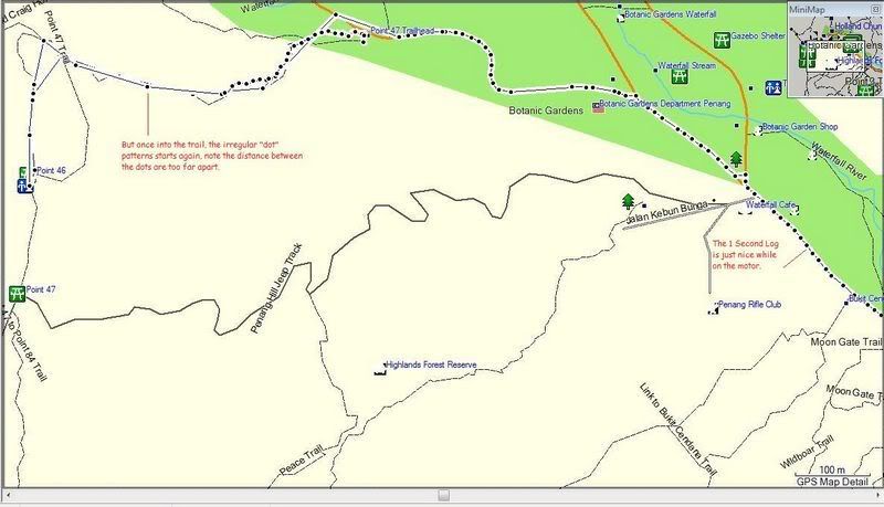
Hi Bro kiwitonita, I just tried out the "Time" 1 second log, works very well when on the road riding my motor but once starts walking into the trail, the "dots" becomes irregular, I am thinking of letting the settings be "auto" and "most often" for the time being, tq for your input. :tq:

Image

redname
Posts: 14
Joined: Mon Apr 13, 2009 4:49 pm

Re: eTrex Series

Postby redname » Mon Jul 06, 2009 2:36 pm

jus a quick check.

1. do u guys use those high speed microsd cards for ur GPS? does it really improve? was tinking of getting a class 6 micro sd but cant find leh, fastest is class 4.

2. how long on avg does ur GPS takes to get a fix? anyway of improving it?

yoladu
Valued Contributor
Posts: 392
Joined: Tue Oct 07, 2008 1:14 pm

Re: eTrex Series

Postby yoladu » Mon Jul 06, 2009 4:00 pm

redname wrote:jus a quick check.

1. do u guys use those high speed microsd cards for ur GPS? does it really improve? was tinking of getting a class 6 micro sd but cant find leh, fastest is class 4.


High speed memory cards are specifically designed for cameras. GPS is not exactly a high speed device, so using high speed memory cards will not improve it's performance.

If the map is unable to redraw itself fast enough, try the Lite version.

redname wrote:2. how long on avg does ur GPS takes to get a fix? anyway of improving it?


It mainly depends on the GPS.

New generation GPS have better hardware such as high sensitive receiver, so it's faster. Some GPS have improved software, like hotfix, able to predict the positions of the satellites which shorten the acquisition of the initial fix.

Some improvements. You can use radiating antenna; go to an open area with no buildings around, in the middle of the sea with horizon all round is the best; stay stationary. Another method is do not off your GPS :mrgreen:

Some examples. based on my experience, of acquisition time from cold start :

- Magnavox Navigator about 1 day :zzz:
- Magellan GPS (used in Desert Storm) about 3 hrs after you key in the estimated position, and datum ](*,)
- eTrex Legend C, about 15 mins :shock:
- eTrex Legend HCx and 60CSx about 1 -2 mins :thumbsdown:
- Nuvi 200W about 4 - 5 mins :ko:
- Nuvi 205, and 550 below 1 min. :thumbsup:
Contribute exclusively to MFM. MSM don't get it !

kiwitonita
Posts: 4
Joined: Tue Feb 24, 2009 4:28 pm
Location: Christchurch, New Zealand
Contact:

Re: eTrex Series

Postby kiwitonita » Mon Jul 06, 2009 4:11 pm

lfy81 wrote:Hi Bro kiwitonita, I just tried out the "Time" 1 second log, works very well when on the road riding my motor but once starts walking into the trail, the "dots" becomes irregular, I am thinking of letting the settings be "auto" and "most often" for the time being, tq for your input.

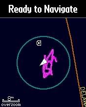
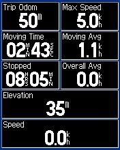
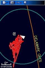
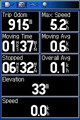
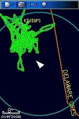
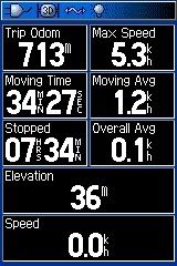
Hi again, glad the 1 sec logs worked out but that poor track logging in the bush is a puzzle! Normally it's a lot better. The eTrex H series seem to have a better antenna than the 60 an 76 series - well, much less track wander anyway. I noted this on our local forum here but will show the screen shots here - the Legend HCx had a lot less wander when inside on my office table than the 60CSx and 76CSx:

Legend HCx:
Image Image

60CSx:
Image Image

76CSx:
Image Image

I don't know what to suggest next sorry. You have obviously tried updating the software so hopefully someone more familiar with the terrain and local conditions will be able to help. All the best, Tony.

User avatar
fauzee
Polygon Mapper
Posts: 1243
Joined: Fri Feb 06, 2009 9:19 pm
Location: JB and Muar -200W & 60Csx

Re: eTrex Series

Postby fauzee » Mon Jul 06, 2009 5:09 pm

yoladu wrote:
redname wrote:jus a quick check.

1. do u guys use those high speed microsd cards for ur GPS? does it really improve? was tinking of getting a class 6 micro sd but cant find leh, fastest is class 4.


High speed memory cards are specifically designed for cameras. GPS is not exactly a high speed device, so using high speed memory cards will not improve it's performance.

If the map is unable to redraw itself fast enough, try the Lite version.

redname wrote:2. how long on avg does ur GPS takes to get a fix? anyway of improving it?


It mainly depends on the GPS.

New generation GPS have better hardware such as high sensitive receiver, so it's faster. Some GPS have improved software, like hotfix, able to predict the positions of the satellites which shorten the acquisition of the initial fix.

Some improvements. You can use radiating antenna; go to an open area with no buildings around, in the middle of the sea with horizon all round is the best; stay stationary. Another method is do not off your GPS :mrgreen:

Some examples. based on my experience, of acquisition time from cold start :

- Magnavox Navigator about 1 day :zzz:
- Magellan GPS (used in Desert Storm) about 3 hrs after you key in the estimated position, and datum ](*,)
- eTrex Legend C, about 15 mins :shock:
- eTrex Legend HCx and 60CSx about 1 -2 mins :thumbsdown:
- Nuvi 200W about 4 - 5 mins :ko:
- Nuvi 205, and 550 below 1 min. :thumbsup:

exactly correct..mine 200w & 60csx.. :cry: :cry: still cannot beat the cheaper one 205.. :$gone: :$gone:
~Lost Is Nothing~
...PLEASE INSTALL THE LATEST MAPS BEFORE DOIN' SOMETHIN'...

lfy81
Posts: 27
Joined: Sat Mar 28, 2009 3:23 pm
Location: Penang (Garmin Legend HCx)

Re: eTrex Series

Postby lfy81 » Mon Jul 06, 2009 5:25 pm

kiwitonita wrote:
lfy81 wrote:Hi Bro kiwitonita, I just tried out the "Time" 1 second log, works very well when on the road riding my motor but once starts walking into the trail, the "dots" becomes irregular, I am thinking of letting the settings be "auto" and "most often" for the time being, tq for your input.

Hi again, glad the 1 sec logs worked out but that poor track logging in the bush is a puzzle! Normally it's a lot better. The eTrex H series seem to have a better antenna than the 60 an 76 series - well, much less track wander anyway. I noted this on our local forum here but will show the screen shots here - the Legend HCx had a lot less wander when inside on my office table than the 60CSx and 76CSx:

Legend HCx:
Image Image

60CSx:
Image Image

76CSx:
Image Image

I don't know what to suggest next sorry. You have obviously tried updating the software so hopefully someone more familiar with the terrain and local conditions will be able to help. All the best, Tony.


Hi Bro kiwitonita, thanks for the photos, the Legend HCx looks the best, less "wandering" compared to the 60CSx and 76 CSx, this morning before getting into the trail, I let the settings at "auto" and "most often", that is the best setting I am using right now.

The Legend HCx is good device, just sometimes, when moving about in a jungle, the accuracy went "OFF" just like that. I am still experimenting with the settings to get the best accuracy when on the trail. :tq:

User avatar
fauzee
Polygon Mapper
Posts: 1243
Joined: Fri Feb 06, 2009 9:19 pm
Location: JB and Muar -200W & 60Csx

Re: eTrex Series

Postby fauzee » Mon Jul 06, 2009 6:16 pm

lfy81 wrote:The Legend HCx is good device, just sometimes, when moving about in a jungle, the accuracy went "OFF" just like that. I am still experimenting with the settings to get the best accuracy when on the trail. :tq:

u mean automatically 'off'..never appears Lost Satellite Reception.. :-? :-?
something goes wrong.. :shock:
~Lost Is Nothing~
...PLEASE INSTALL THE LATEST MAPS BEFORE DOIN' SOMETHIN'...

lfy81
Posts: 27
Joined: Sat Mar 28, 2009 3:23 pm
Location: Penang (Garmin Legend HCx)

Re: eTrex Series

Postby lfy81 » Mon Jul 06, 2009 6:22 pm

fauzee wrote:
lfy81 wrote:The Legend HCx is good device, just sometimes, when moving about in a jungle, the accuracy went "OFF" just like that. I am still experimenting with the settings to get the best accuracy when on the trail. :tq:

u mean automatically 'off'..never appears Lost Satellite Reception.. :-? :-?
something goes wrong.. :shock:


The accuracy went off, becomes less accurate. :)

User avatar
keong8260
Regional Mapper
Posts: 1828
Joined: Fri Sep 19, 2008 4:29 pm
Location: Alor Setar (60CSx, Nuvi, Papago, Polnav, Galactio, Compass, Parang, Gun)
Contact:

Re: eTrex Series

Postby keong8260 » Mon Jul 06, 2009 11:58 pm

lfy81 wrote:
fauzee wrote:
lfy81 wrote:The Legend HCx is good device, just sometimes, when moving about in a jungle, the accuracy went "OFF" just like that. I am still experimenting with the settings to get the best accuracy when on the trail. :tq:

u mean automatically 'off'..never appears Lost Satellite Reception.. :-? :-?
something goes wrong.. :shock:


The accuracy went off, becomes less accurate. :)


From what I experience, normal 60csx accuracy is between 2m ("very" open clear sky) - 5m, but under heavy forest shade, accuracy is normally between 4 - 6 meter. What about eTrex?


Return to “GPS Devices”

Who is online

Users browsing this forum: No registered users and 11 guests