Page 3 of 11
Re: Tracklogs for Singapore (Q2 2009)
Posted: Sat Apr 11, 2009 9:17 pm
by JJ007
Just to check if mapper intended to capture track on recreational path like Bukit Timah Nature Reserve, Macritche Reservoir, etc etc
This morning walk .
viewtopic.php?p=32304#p32304 (but I think accuracy is out of question lah)
If so, I will walk more ....

(or you just trace from GE lah), find it useful when do tracking lah ..
Thanks! - OngCC
Re: Tracklogs for Singapore (Q2 2009)
Posted: Sun Apr 12, 2009 2:05 pm
by joeyao
v1.52
Uncharted pedestrian walkways.
Thanks! - OngCC
Re: Tracklogs for Singapore (Q2 2009)
Posted: Mon Apr 13, 2009 7:30 am
by coolerbok
Track not in Map
Active Log 6 & 12 - Track of slip road into Marina Barrage car park. The track beyond POI named "Marina Barrage Car Park" is by foot and not accessible by car. You may not want to build this portion into the map as it is a walk around the Complex and to 2/3rds of the Marina Bridge.
POI not in map
1 Marina Barrage Car Park
2 Marina Bridge
3 Builders Centre (Commercial Building at Changi South)
4 Tang Logistic Centre (Commercial Building at Changi South)
5 Entrepreneur Centre (Commercial Building at Tagore)
6 Maison Royale (Condo at Newton)
7 Suites @ Surrey (Condo at Newton)
eTrex Vista HCx, no external antenna, 1 sec, lock off.
Cheers.
Thanks! - OngCC
Re: Tracklogs for Singapore (Q2 2009)
Posted: Tue Apr 14, 2009 11:12 pm
by deepict
Extension of Pasir Ris Drive 4
Thanks! - OngCC
Re: Tracklogs for Singapore (Q2 2009)
Posted: Fri Apr 17, 2009 4:32 pm
by ace
Couple of updates...
Compassvale Bow (new)
1. Compassvale Bow is now extended from Sengkang Central to Sengkang East Road.
Note 1: Sengkang Central into Compassvale Bow is a cross junction.
Note 2: Compassvale Bow to Sengkang East Road is a T-junction.
2. POI -Majid Al-Mawaddah Mosque. For better routing as the carpark is from the side road after Compassvale Bow.
Punggol End
1. There is a carpark track with direction pointing to Outward Bound Singapore Reception Centre.
2. The Punggol Pt Holiday Camp POI looks like it has been renamed Outward Bound Singapore Reception Centre
Punggol East
1. A couple of turns (U-turn and Right-turn) from Punggol Field Walk to Punggol East.
Note 1: The U-turn need to be resited.
Note 2: The right turn is only one way into Punggol Field Walk... Cars coming out of Punggol Field Walk must make u-turn at Punggol East road.
Thanks! - OngCC
Re: Tracklogs for Singapore (Q2 2009)
Posted: Mon Apr 20, 2009 12:20 am
by joeyao
v1.54
Outline of Changi Creek Reservoir and canal that has not been drawn in the latest map. Please ignore if it is in the process of being drawn. Thanks.
Thanks! Was covered by airport polygon. - OngCC
Re: Tracklogs for Singapore (Q2 2009)
Posted: Tue Apr 21, 2009 10:22 pm
by joeyao
v1.54
A couple of uncharted streams.
Thanks! - OngCC
Re: Tracklogs for Singapore (Q2 2009)
Posted: Tue Apr 21, 2009 11:00 pm
by joeyao
v1.54
Some uncharted ponds in Pulau Ubin.
Thanks! - OngCC
Re: Tracklogs for Singapore (Q2 2009)
Posted: Thu Apr 23, 2009 6:06 pm
by joeyao
v1.54a
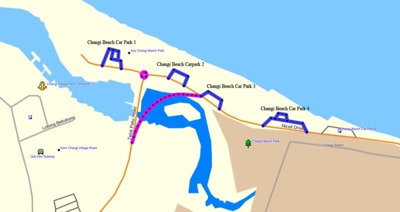
Changi Beach Car Parks 1 to 4.
Uncharted circus.
New uncharted road.
 Thanks! - OngCC
Re: Tracklogs for Singapore (Q2 2009)
Posted: Thu Apr 23, 2009 9:53 pm
by joeyao
v1.54a
2 uncharted ponds:
Pasir Ris Town Park Pond
Tampines Quarry
Thanks! - OngCC
 (or you just trace from GE lah), find it useful when do tracking lah ..