Longitude - 101 degree 51' 57.1"
Latitude - 2 degree 25' 18.6"
-done- 2.77


Free Galactio, Garmin, iGO Primo, Papago and Polnav map for Malaysia, Singapore, Brunei, Indonesia and Thailand
Moderators: 9W2CBL, Moderators, Regional Mappers
ben0488 wrote:The location found for Methodist Center, Port Dickson is wrong. Please take note to correct the coordinates with the following -
Longitude - 101 degree 51' 57.1"
Latitude - 2 degree 25' 18.6"
fancheng wrote:ben0488 wrote:The location found for Methodist Center, Port Dickson is wrong. Please take note to correct the coordinates with the following -
Longitude - 101 degree 51' 57.1"
Latitude - 2 degree 25' 18.6"
Coordinate N2.52226 E101.79181 is Port Dickson Chinese Methodist Church and coordinate above is Methodist Center, anyone can confirm ?


tympg wrote:Bro,
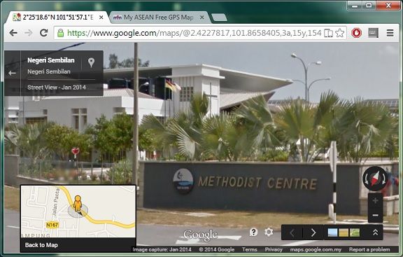
Using Google Street View @ N2.4227817 E101.8658405 I see this:
(click on image to go directly to Google Maps)
[url=https://www.google.com/maps/@2.4227817,101.8658405,3a,15y,154.2h,90.18t/data=!3m4!1e1!3m2!1s2ggkQ3C59LvEfJSbBhiyGA!2e0]
so ben0488's coordinates are not far off for Port Dickson Methodist Centre.
sobamy wrote:Yes, I can confirm it's the PD Methodist Centre. I was there two weeks ago attending a summit.

Return to “N.Sembilan Map Feedback”
Users browsing this forum: No registered users and 10 guests