Hi there, I am a 54 year old 'Brit', married to a Filipina (7 years), living in Cebu, Philippines, having both left Hong Kong in May 2001.
I retired early as the relatively low cost of living in the Philippines, allowed me to do so.
The Nokia N95 8GB mobile phone is fantastic as it does so much, and so many applications available. Whilst it does indeed have internal GPS, I also bought an external Bluetooth unit -
WinTec, G-Rays 2, WBT-201. The reasons are many, but reliability, accuracy and ability are the main ones.
To use the internal N95 GPS, you have to open the slider, then activate a suitable Tracking Program (Nokia Sports Tracker, or GPSed). It can take a LONG time (>10 min?) for the Nokia N95 GPS to synch with available Satellites. The WBT-201 unit, remembers the GPS fix, and does a 'warm start'. So unless the battery has gone flat, it only takes 3-5 mins to get a 'fix'.
The WBT-201 can be positioned to give clear unobstructed view of the satellites, whereas the Nokia N95 can sit on the dashboard, if you want to read it. Position it to be convenient to use, and it not optimal for receiving NMEA data from satellites.
I was not keen on strapping my Nokia N95 to the handlebars of my Yamaha XT225 either where vibrations might damage it and a sudden downpour might kill the N95 if rain gets in. So much better to strap thethe tiny weatherproof WBT-201 to my Motorbike - feeding the NMEA Data (or just storing it, for access later), to N95 for viewing on Google Maps - which has just been upgraded to
V3.2and is now fantastic to use.
The other areas, where the external Bluetooth, WBT-201, G-Rays 2, dedicated GPS 'logger', is superior to the internal Nokia N95 GPS, is not just speed to get a fix, or accuracy, but the ability to configure the tracking points to be acquired by i) Time interval, ii) Distance travelled, iii) Angle deviation from existing bearing, or combination's of these, and there is 'Auto-Pause' where it does not collect any data if below a certain speed (so when stationary or just looking around, it is not logging data, that is often inaccurate anyway). This means for example you could have it set to collect every 10 seconds, but if you travel more than say '5m', iot will get new GPS data, and also if you change direction by say 1 Degree, than new co-ordinates collected. This is lot better than simply collecting every 1 second to get good tracks.
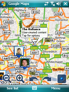 Google Maps 3.2
The latest version comes with many advance features. The concept of layers in this version allows you to view many layers of information on your map at the same time.
Now you can interact with geographic content, like public transit, traffic (with incidents!), local search results, Latitude friend locations, Wikipedia much more easier and useful than before. More information on this release is available on Google Mobile Blog.
Google Maps for mobile Layers is available now on Symbian S60 and Windows Mobile phones, and will come soon to other platforms. The upgrade is available for all countries where Google Maps for mobile is currently available. To get it on your phone, go to m.google.com/maps.
I am new to Mapping and have recently loaded
GARMIN Mobile XT on my
Nokia N95 8GB and keen to improve
Digital Maps of the Philippines, especially Cebu.
David Whittall newbie in the house.
 aboard the MfM ship.
 ..new comer here..from Merlimau,Melaka..
